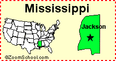
Description: Map of Mississippi
Image copyright: http://www.enchantedlearning.com/usa/gifs/mississippicap.GIF
Date it became a state: December 10, 1817
Governor: Haley Barbour
Land Area: 46,906.96
States Surrounding it: Alabama, Arkansas, Louisiana, and Tennessee
State Nickname: Magnolia state
State Motto: Virtute et armis (By valor and arms)
State Mammal: White tailed dear
State Bird: Mocking bird
State Tree: Magnolia tree
History (5 important events):
1. Hernando de Soto discovered the Mississippi river.
2. After the French and Indian wars Great Britain took over the area.
3. Shortly after the state’s Great Depression, cotton was the undisputed king of its economy.
4. In 2001 more acres of cotton were planted than soybeans and Mississippi became second in the nation in the cotton production.
5. A French group under Sieur d’ blervelle established the first permanent settlement in 1999.
Geography (Describe the land, rivers, mountains, lakes, etc):
There are many rivers such as the Mississippi river, Tennessee river, and the Yazoo rivers. There is also a forest called The Piney Forest.
Attractions/Places to Visit:
1. Marine Life Oceanarium-Joseph T. Jones Memorial Pa
2. Ship Island Excursions/Pan Isles Inc.
3. Buccaneer State Park
Other Interesting Facts:
The state song is “Go Mississippi.”
The state water mammal is the Bottlenosed Dolphin.
Milk is the state beverage.