|
Air Masses & Fronts Chapter 3 Section 1
|
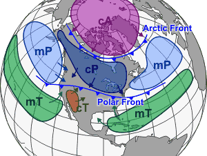
Picture taken from National Weather Service website.
|
Picture taken from National Weather Service website. |
|
In-Class Assignment for Monday Dec. 3 Last week we began learning about air masses and fronts. Today we will go further in exploring these topics. You will be given a printed copy of the questions below. Visit the websites listed below to find the answers for each question. You should record your answers on your paper. Site 1 1. What is an air mass? 2. Where do polar and tropical air masses develop? (Give the approximate latitudes.) 3. For each of the four air masses, what is the description this website gives? Site 2 4. Why is the United States not a great place for air masses to form? Site 3 5. This site describes five basic types of air masses. In class on Friday, we learned about four types. Write the name of the ōnewö air mass and give two important facts about it. 6. Label the air masses on the map with the appropriate abbreviation. 7. What do the letters ōKö or ōWö mean when attached to an air mass? 8. When does America have typically have its most violent weather? Why? Site 4 9. In the first illustration, what kind of air mass is passing over the region? What type of weather will it bring? 10. In the second illustration, what kind of air mass is passing over southern California? What type of weather will it bring? Site 5 11. Click on the ōCold Front.ö What happens in the illustration? 12. Click on the ōWarm Front.ö What happens in the illustration? 13. In both the cold front and the warm front, warm air rises and cold air stays near EarthÆs surface. How are they different? Site 6 14. What is a cold front and in what direction does one typically move? 15. How are cold fronts represented on a weather map? 16. From the chart at the bottom of the page, what happens to the wind as a cold front passes through? What about the precipitation? Site 7 17. What is a warm front and in what direction does one typically move? 18. How are warm fronts represented on a weather map? 19. From the chart at the bottom of the page, when a warm front passes through an area, what happens to the temperature and precipitation levels in that area? Site 8 20. What is a stationary front and what type of weather does one typically bring? 21. What is the weather map symbol for a stationary front? Site 9 22. How does an occluded front form? 23. What is the weather map symbol for an occluded front? Site 10 24. Visit the site listed above and see how well you do at locating the air masses. (Hint: Start with exercises 3 and 4 then go back to complete 1 and 2.) Once you complete this page, have Ms. Bumgarner initial your worksheet. Site 11 25. Got to the above website and answer all 15 questions. When you finish, write down your score as the number you got right (out of 15) and the percent (out of 100) it equals. Before you record your final score, have Ms. Bumgarner initial your worksheet. |
Links: |